Border physical security software
Persistent Sentinel has more than 15 years of experience developing and deploying border security software. Our HiRSA software integrates sensor and surveillance systems including legacy technologies. HiRSA has been deployed for more than 12 years of continuous border operations on an international border within a challenging environment.
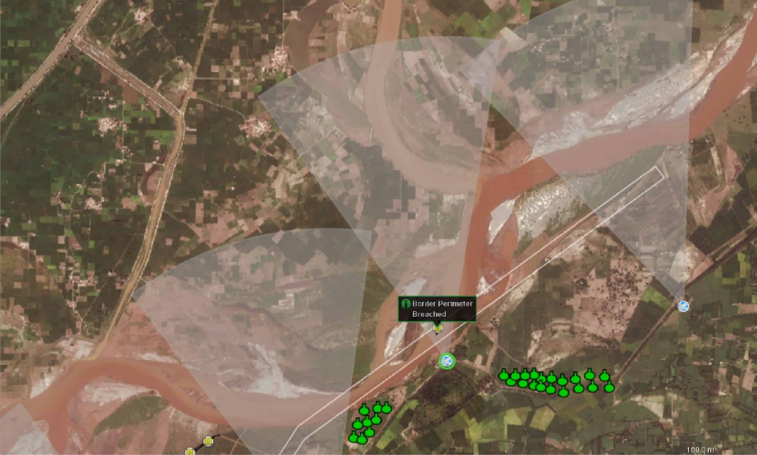
HiRSA gathers information from connected sensors and systems to produce a networked common operating picture (COP) for security forces. HiRSA operates as a networked system with processing nodes at remote sensor locations connected to command centers. Command centers can be linked creating a hierarchical structure with each command center responsible for their own remote sensors, but at the same time share information with other command centers. Our architecture is extremely scalable and can provide security at a single critical point, or the large area of a national border.
expand
HiRSA provides an extensive Geographic Information System (GIS) with sensor locations visualized over satellite imagery providing operators with a complete security picture. HiRSA has an extensive decision support system that uses a combination of automated alerts with actions and user task lists to respond to events. The software automatically evaluates sensor information and provides tailored Warning /Cautions/Advisories (WCA) with recommended courses of action and task lists. Administrators configure the agent logic to determine which event types to monitor, during what time of the day, and in what geographic area. The relevant information is automatically opened and highlighted by the software so the operator can easily access the situation. This includes centering the GIS screen on the event as well as opening associated floor plans if the event is inside a building. On a triggered event, multiple cameras can be automatically directed towards the threat location to verify the event, begin surveillance, and eliminate false alerts.
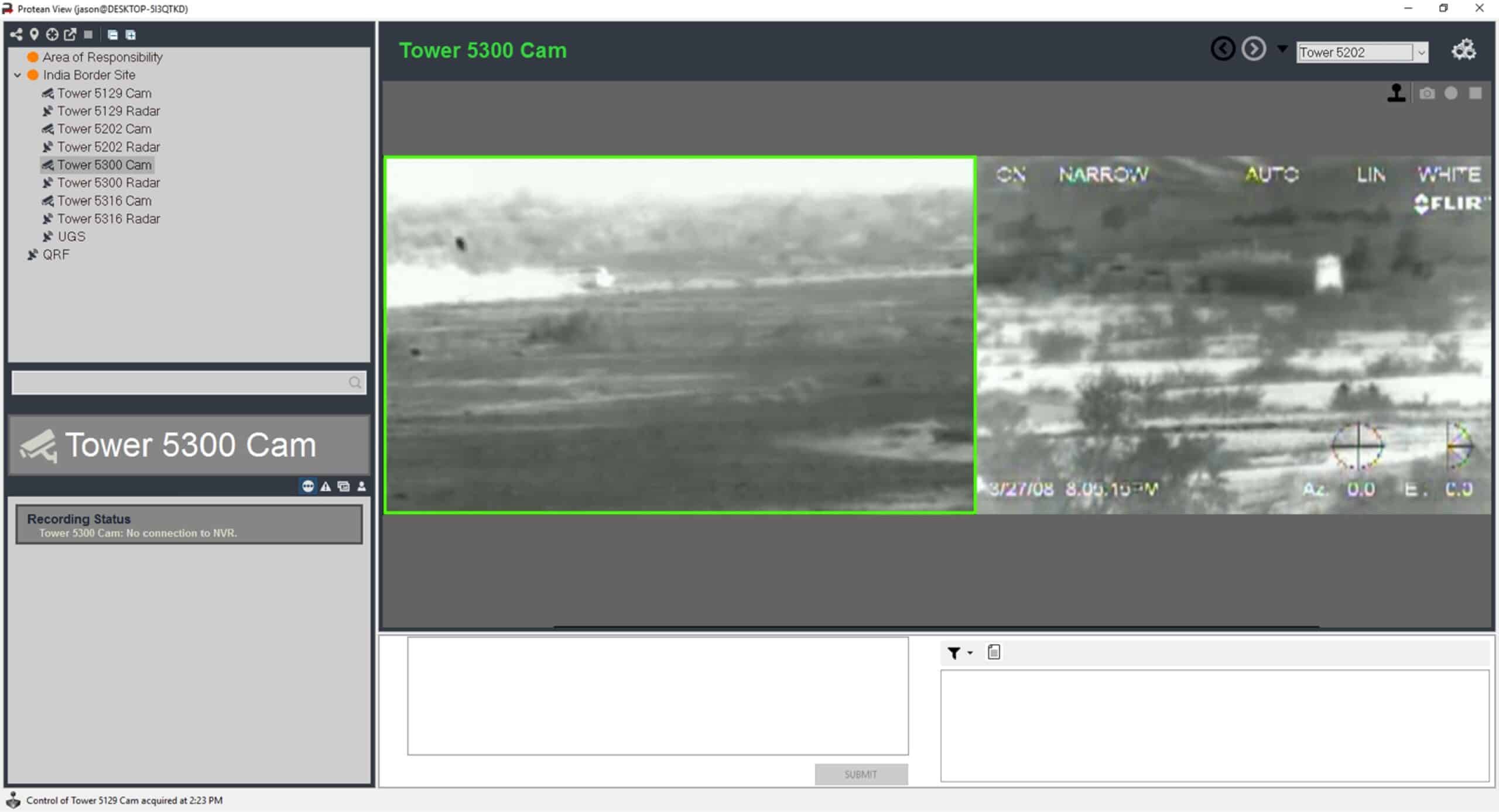
HiRSA’s Network Video Recorder (NVR) continuously buffers video from the configured cameras that are attached to the system. The Operators can easily retrieve video from the buffer as well as record video snippets for specific events. Along with the buffered video the NVR acts as a historical recorder for the system recording all meta-data including events, operator alerts, sensor coverage areas, etc. Operators can easily search geographic areas to find recorded video and event information to reconstruct an event from beginning to end. The system will show all cameras that were able to see the specified area during the specified time, this gives operators the opportunity to possibly find more angles for an event.
HiRSA is proven to work with a variety of sensor systems including Radars, Sonars, Fence Vibrations Detection Systems, Electronic Tamper Systems and Unattended Ground Sensors (UGS). HiRSA can fully integrate with the sensors that are connected to the system allowing operators to control all aspects of the sensors as well as see the event and track data from the sensors.
HiRSA’s report module provides the capability to create custom report templates for status reports, incident reports, etc. Re-occurring reports can be automatically scheduled and automatically created. Reports can be shared with other users as well as saved as PDF files and printed. Combining the reporting system with the internal chat system allows operators to work together seamlessly.
HiRSA’s trending module provides a set of statistical analysis and trending tools for monitoring the frequency of events in the system. HiRSA will automatically track the number of events, alerts, and sensor status information, giving an analyst a break down by hour, week, or month. The trending system will also highlight the time periods when the number events, alerts, and sensor status information is outside the normal for that given time period. HiRSA provides the ability to display statistical information for any of the areas configured in the system as well as the current area displayed on the GIS display.
collapse
Key Features/Benefits:
- Integrates ANY border sensor or surveillance system, including legacy technologies.
- Highly customizable and scalable system integration software.
- Proven and deployed land BORDER COMMAND system.
- Collects and analyzes data from all data sources to create a detailed high-resolution GIS operational display.
- Distributed and hierarchical command and control.
- Enables enhanced situational awareness for the operators.
- Reports and Trending modules.
- Generates tailored alerts and response actions for the operator.
- System redundancy, failover and health monitoring.
- Enhanced database management system and network video recorder.
- Developed with and tested by the US Navy and US Army.